In a lengthy accident investigation report released earlier this month that claimed the lives of six men in July 2023, the Transportation Safety Board (TSB) cited inclement weather enroute and pilot decision making as the leading factors.
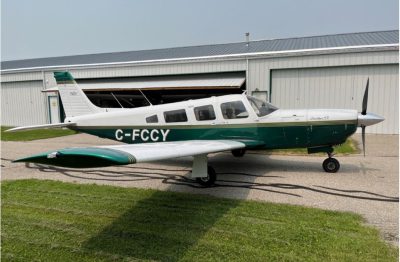
The VFR flight departed Calgary/Springbank Airport (CYBW) destined for the Salmon Arm Aerodrome (CZAM). On board the six-seat Piper-32R-301 (Saratoga SP) aircraft was the pilot and five of his friends, all bound for a social event in Salmon Arm. The pilot had previously made the trip numerous times in a Piper Cherokee 180. This was the first in the recently acquired Saratoga.
The investigators determined that the pilot had not contacted Flight Services for a weather briefing, nor did he file a flight plan, though he did leave a flight itinerary with a responsible person. The pilot reportedly consulted an unknown online weather service before the flight.
Although the destination weather was favourable for a VFR flight at the destination and in general west of the Rockies, low overcast conditions existed east of the Rockies, and the pilot delayed takeoff, originally planned for 19:30 MDT, to the point where any further delay would have led to an estimated arrival time later than that permitted for a daytime VFR flight. The pilot had neither an instrument rating nor a night rating.
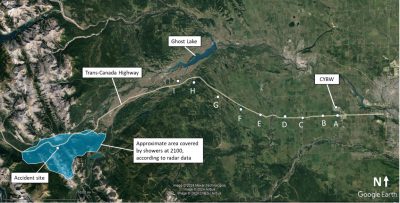
The flight was eventually airborne at 20:47 MDT and levelled off at 5,500 feet, which is the planned altitude he had reported to ATC at Springbank. He had earlier informed ATC his plan was to take the designated VFR route that follows the Trans Canada Highway through the Rockies.
Before losing radar contact due to surrounding terrain, the data showed that the aircraft maintain an altitude of 5,500 feet plus or minus 300 feet following the highway and at a ground speed of 150 knots. The last radar hit at 20:56 indicated the aircraft was at 5,800 feet, still at 150 knots. At around 21:03, the Saratoga impacted the east face of Mount McGillivray at an altitude of 6,500 feet and the aircraft was destroyed.
At 21:37, an overflying aircraft picked up an Emergency Locator Transmitter (ELT) signal on 121.5 MHz and reported it to ATC. Over two hours later, at 23:40, the responsible person with the flight itinerary reported the overdue aircraft to the Joint Rescue Coordination Centre in Victoria. The wreckage was found the next morning.
The TSB investigators, with the assistance of meteorologists, determined that cloud and rain, indicated by Nav Canada’s weather records at the time of the flight, was encountered by the pilot and which led to the crash.
The TSB report states that, “When the pilot encountered clouds and reduced visibility, for unknown reasons, he decided to continue the flight toward the destination and, subsequently, the aircraft collided with terrain in the cruise attitude.”
The complete TSB report can be accessed by clicking here.